
You know it’s rather easy to mock Americans for their stupidity but at some point you have to have a little patience and understanding because little American kids are constantly being spammed by misinformation.
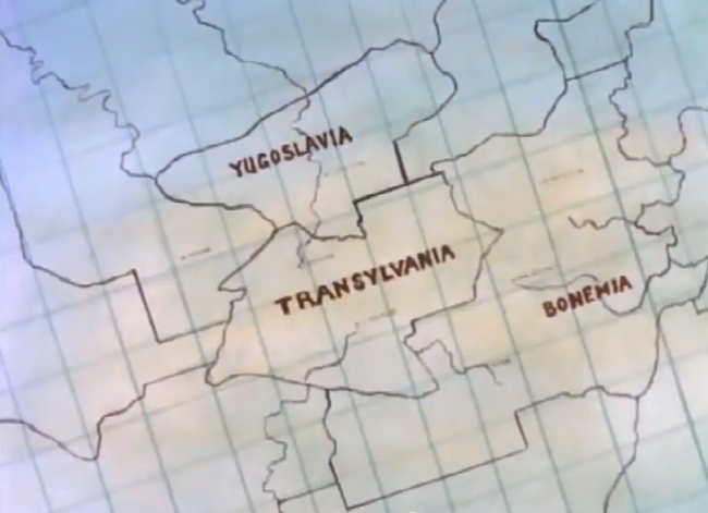
Case in point is the map above, which incredibly wrong on so many levels. This is a screenshot from a 1984 cartoon so Yugoslavia did, in fact, exist at the time but was far, far larger than pictured here (it’s now split into between 5 and 8 different countries, depending on whom you ask). Likewise, Bohemia (a region of the Czech Republic) is far smaller than pictured here while the shape of all three regions is just completely wrong. And they’re not even oriented correctly as the Czech Republic is the furthest west, followed by Yugoslavia and then Transylvania being the furthest east.
The cubist graph paper it’s written on has a European flavor to it since it was only somewhat rarely used in the United States in those days but it’s obvious that the artist is 100% American. You can tell this because the only place in the world with straight line borders is in the United States between the various states. I guess technically some African borders also have straight, clear-cut lines but considering that this map comes from an American cartoon, we’ll assume that the artist was channeling his/her “knowledge” of American geography for inspiration.
What’s especially weird is that while Yugoslavia was a sovereign nation in 1984, neither Transylvania nor Bohemia (btw it’s actually spelled correctly on the map, it’s just that the graph paper line makes the “H” look more like an “N”) were ever independent countries in their own right. Quite frankly it looks like someone told an American artist “hey draw a map with Transylvania” and Bohemia and Yugoslavia were the only other “Eastern” European locations that they could think of.
This map is from an episode of “Spider-Man & His Amazing Friends”, a 1984 episode called “The Bride of Dracula”, filled with all kinds of other absurdities plus a heavy dose of misogyny. I can’t say for sure if I ever saw this specific episode when I was younger but I know for sure I was watching this cartoon regularly on Saturday mornings in those days so it’s damn near miraculous that I ever managed to overcome such an avalanche of misinformation and stereotyping.
I guess it helps that my parents could afford an actual fucking map for us kids. Even before the invention of the internet, paper maps and “globes” were really not that expensive or hard to get, even if they were the racist Mercatur kind.
Thanks to the wonders of YouTube, you can watch this poorly-written garbage in its entirety:
Besides all of the other faults in this episode, what also struck me as bizarre is that this “map” is seen by Spider-Man as he leers through the window of the airplane cockpit. This map that we see is supposedly what the pilot is using for navigating on his flight to Transylvania.
Were there no computers in airplanes in those days? Were pilots really using pen and ink maps drawn on graph paper, maps that failed to show a single city or airport but yet had rivers delineated?
Also the so-called “plot” of the episode involves a commercial airliner leaving from somewhere in the United States on a direct course to Transylvania. Really? Was there ever a single direct flight from America to anywhere in the Communist bloc in the 1980s?
I know, I know, I’m obviously thinking way too much about this but the whole premise of this episode just fails on so many levels. The writers clearly just wanted to shoehorn in a Dracula plot and didn’t care about anything else (like geography or common sense).
Still though, it goes to show you just why everyone “knows” vampires come from Transylvania even when they have no earthly idea where Transylvania is LOL.
AND NOW YOU KNOW!

When I went to school in the US, geography was not in the curriculum – I always wondered why. It seems more emphasis was placed on time spent in school vs out of school (more meant better) rather than what was actually taught. Maybe because there’s less ability-based segregation there, so it takes longer to teach a concept to kids of different abilities rather than to just one subset. But the stereotypes of Eastern Europe or any other part of the world generally come from pop culture, not school.
LikeLike
It’s simple… The map above is bad, actually terrible. Point. So the american kids should not take that map as valid. Point. It’s like a bad telegram(and that resumes it all) :D
LikeLike
Actually we are pretty stupid on our own. With conservatives doing their best to destroy public education, things like geography get dropped as money becomes more scarce. Wait, we could also blame this on our (USA) isolationist tendencies. Why would need to know anything about any where outside our home town if all we need is here…thing? No, no, there could be that America 1st thing…umm nationalism? If we are the greatest why do we need to know anything about anyone else? I’m sure I’m missing a few more…It’s hard being the youngest…
LikeLike
Yeah, cause public education produced such wonderful results, especially in liberal/socialist bastions (dc, detroit, etc) where most tenth graders can’t even read, and have not been able to memorize the multiplication table. Mind you, those are places with the biggest public education budgets (per pupil)
Everything’s the fault of conservatives of course, what a clever original outlook.
Disclaimer: I, personally, am not a conservative.
LikeLike
This map isn’t just a a collection of Eastern European names: if you consider the top to be south, Bohemia a replacement for Czechoslovakia, that map is an approximation for the this part of Europe in the 1920s. Maybe it’s what the writer remembers from school about Eastern Europe.
LikeLike